
Does Paradise Need a Parking Lot?
Back to Contents of Issue: March 2003
|
|
|
|
by Michael E. Standley |
|
 IT GETS TIRESOME HEARING how "unique" Japan is; how the tea ceremony or the practice of Zen, for example, are parts of a special whole found only in this archipelago. So much of that "whole," like the tea ceremony and Zen, actually has roots elsewhere. Geographically, however, Japan is a one-off oddity, reaching from the cold, temperate climate of its northernmost isles to the bright, coral-girt islands at its far southern end. The nation's capital is even more unusual, having what is undoubtedly the world's most isolated suburb: islands -- some clothed in tropical green, others bare and sere -- scattered across the Pacific almost a thousand kilometers from the hustling, crowded warren of its downtown streets. IT GETS TIRESOME HEARING how "unique" Japan is; how the tea ceremony or the practice of Zen, for example, are parts of a special whole found only in this archipelago. So much of that "whole," like the tea ceremony and Zen, actually has roots elsewhere. Geographically, however, Japan is a one-off oddity, reaching from the cold, temperate climate of its northernmost isles to the bright, coral-girt islands at its far southern end. The nation's capital is even more unusual, having what is undoubtedly the world's most isolated suburb: islands -- some clothed in tropical green, others bare and sere -- scattered across the Pacific almost a thousand kilometers from the hustling, crowded warren of its downtown streets.These islands, called the Ogasawaras, have tantalized developers for decades. Plans on the table would turn those isolated suburbs into Japan's very own Waikiki. But at what environmental cost? The answer to that question is being shaped right now. When you think of the Ogasawara island chain, think of Bermuda as part and parcel of New York City, or of Madeira as a distant fragment of London; these comparisons pretty much convey the relationship -- and contrast -- between the monstrous grey metropolis of Tokyo and what is termed Ogasawara-mura -- "Ogasawara village," Tokyo's farthest-flung suburb. This isolated "village" -- actually an ecologically remarkable archipelago with an exotic history that at times seems straight out of a novel -- consists of several clusters of volcanic islands and one small coral islet, all of which sit atop great peaks rising from the abyssal gloom of the Pacific's floor. Their distance from any other landmass has resulted in these islands being home to a menagerie of unique and unusual species; some Japanese naturalists refer to them as "Japan's own Galapagos." The difficulty of access from Japan's main islands has so far kept the Ogasawara chain fairly safe from the construction industry juggernaut that has torn up and paved over much of Japan's landscape. But a treasure such as these islands is not easily ignored when there is money to be made, especially when the islands are an in-country paradise with much potential appeal to the travel-hungry populace of Japan. A rich history Ogasawara-mura includes several clusters of islands having a total land area of about 100 square kilometers, with the "traditional" Ogasawaras -- often called the Bonin Islands in English -- forming the largest group. To avoid confusion, let's use the term "Bonins" to refer to these islands specifically, and the term "Ogasawaras" to refer to all of these far bits of Tokyo taken together. The 30 or so Bonin Islands (depending on the chartmaker's whim, sometimes a rock is a small island or a small island is a rock) are just slightly east of a line drawn due south from Tokyo. They were thrust up from the bowels of the Pacific's bottom some 3 million years ago and have existed in isolation ever since. All species that exist on them rode the wind or waves from somewhere else. These islands were originally covered with a thick subtropical rain forest, a rich ecosystem that provided countless ecological niches for arriving species to exploit. This resulted in a profusion of plant and small animal species found here and nowhere else. Alas, many of these have already disappeared; many more are threatened. Two of these islands, Chichijima ("Father Island") and Hahajima ("Mother Island") are inhabited, with a total population of just over 2,500. Although they are part of Tokyo, the weekly 26-hour sea voyage that the journey requires means that it takes longer to get from downtown Tokyo to the Ogasawaras than it does to go from Tokyo to just about any other city in the world.  Archaeological remains found in the Bonins and in the Volcano Islands have shown that an ancient Oceanic race once inhabited some of these islands. A Chinese chronicle of the third century, the Wei Zhi, mentions a "black-teethed people" living on islands far to the south of the islands of Wa, as Japan was then known. Blackening of the teeth was a Micronesian custom that survived into the 20th century, and the Chinese reference may be the earliest record of the Ogasawaras and the only record of the ancient inhabitants, who disappeared for unknown reasons some centuries ago.
The islands lay apparently uninhabited and unvisited until the 16th century, when they were first sighted by a wayward Spanish explorer in 1543 and christened the Arzobispo Islands. The explorer, concerned about his overstretched supplies of food and water, declined to land. It does sound a bit odd -- a bit like saying that being really thirsty means you shouldn't have a drink of water -- considering that such high, forested islands usually have fresh water in abundance. Exactly 50 years later, the Japanese warlord Ogasawara Sadayori was recorded as having discovered these islands after sailing south from the Izu Peninsula. He was completely unaware of the Spanish sighting. The single source for this discovery, however, seems somewhat doubtful. The first Japanese ashore may well have been some off-course Japanese traders carrying a shipload of mikan oranges, who were stranded on the islands after a shipwreck in 1670. There was a further Japanese expedition in 1675. These landings would help confirm Japanese ownership of the islands in years to come. In 1785, a map of Japan showed the "Ogasawara Bunin-To" as a part of Greater Japan. But by that time, Japan had turned inward, effectively sealing itself off from the rest of the world, and long-distance voyages became in most cases a capital crime. Word of these islands leaked out to Europe through the tiny Dutch trading enclave at Nagasaki, and by the early 19th century, American and European vessels had landed in the Bonins. Whaling ships began to call at the islands for fresh water and to lay in rich larder from the astronomical numbers of birds and sea turtles found there. If only that Spanish captain had known of the abundant food and water! Had he landed and claimed the group for Spain, history in this corner of Japan might have taken a very different turn. One of the visiting ships landed some pigs, so as to provide a future meat supply. The population of these marooned animals exploded, and their omnivorous rapacity ensured that anything that might become swine fodder was in danger. The decline of the Bonins' rich endemic heritage began with those released pigs. In 1830, a mixed group -- two Americans, one Briton, one Italian, one Dane (all men) and 15 Hawaiians (both men and women) -- arrived to found a small colony. Later arrivals added to the mix. This small community took root and grew, and only discovered that they were living on Japanese territory in the 1860s, as Japan shook off its feudalism and emerged into the modern world. Japanese settlers arrived to found their own colony, and the two coexisted side by side and in some ways began to coalesce. The original settlers were given Japanese citizenship in 1877, and as the 19th century drew to a close, the islands became a part of Tokyo. 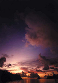 The price of progress
As the population grew into the thousands, the ancient forests were sheared off the island slopes -- the greater portion in less than a decade -- and commercial agricultural development proceeded apace. Turtles and birds were slaughtered in huge numbers, and the rate of extinction among the other unique species of flora and fauna accelerated. Today, tiny remnants of that original forest cover survive only in the farthest and most inaccessible ravines. The land cleared for agriculture has gone wild again; there is no commercial agriculture anywhere in the Ogasawaras, except for small-scale experimental patches of coffee and sugar cane. Cabbages and tomatoes and bean sprouts ride the weekly ship from Tokyo, along with beer and noodles and rice. While the lush and beautiful secondary forest growth of these islands today is only a pale shadow of what once was, it is still a wonder to behold. There are 73 species of endemic trees, 82 species of endemic land snails and 236 species of insects found nowhere else in the world. Some of these species exist in tiny microenvironments and cannot survive anywhere else. Japanese-style intensive development was the order of the day until World War II, when the islands held thousands of Japanese troops. With the exception of 80 able-bodied adult men, who were drafted as laborers, the civilian population of just over 7,700 -- the great majority from Chichijima and Hahajima -- was relocated to mainland Japan. After Japan's defeat, the US Navy occupied the islands. A small military contingent operated a weather station and maintained the base. Recently declassified secret documents have revealed that the small base was a contingency storage facility for nuclear weapons and on at least one occasion such weapons were actually present. In a curious bit of racism, the US government eventually allowed only the descendants of the original non-Japanese settlers -- 129 in total -- to return and resume residence. When Japan regained sovereignty in 1968, the other wartime evacuees and their families could at last go home. Some did, others chose not to, opting instead to sell their landholdings. The purchasers had an idea in mind: build an airport, and develop the islands as Tokyo's own in-city tropical resort destination. Attack on Tokyo To the southwest lie the three islands of the Kazan Retto, meaning -- aptly -- "Volcano Islands." One of them, Ioh Toh, "Sulfur Island," is an active volcano that is better known as the Pacific War battleground Iwo Jima. Ioh Toh has a transient population of about 400 Japanese Self-Defense Forces personnel and representatives of other government agencies, and is home to a large military airfield. The same Spanish explorer who sighted the Bonins apparently landed here in 1543. He was followed by others from rival nations in the late 18th and early 19th centuries. All of them noted the island's lack of water and sulfur stink. None of them claimed it, and in the late 19th century it became Japanese territory almost by default. A village was established on the island early in the 20th century, and the islanders managed to eke out a hardscrabble living until they were evacuated with the other Ogasawara islanders in 1944. The battle between the defending Japanese forces and the invading US Marines in February 1945 has become a near legend, but one fact is often overlooked: Usually, the invasion of Okinawa in April 1945 is marked as the first incursion of US forces onto the territory of Japan. However, Ioh Toh was (as it is today) part of Japan's capital itself, and that real first incursion took place within the Tokyo city limits. 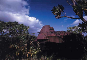 Ioh Toh is volcanically active, with a huge column of magma slowly rising directly under the island. It has risen over six meters since the 1945 invasion, and volcanologists believe that it will continue to do so until the bursting point is reached and the island goes up in a Krakatau-like explosion.
Far to the east lies the solitary coral speck of Minamitori-shima, "South Bird Island." It is often shown on English-language maps as Marcus Island. This tiny, flat, triangular island, one of the farthest-flung inhabited bits of land in the Pacific, has a transient population like that of Ioh Toh that numbers only about 50 or so. It was discovered in the mid-19th century and, like Ioh Toh, fell to Japan almost by default. No other nation cared to claim it or act on claims made in its name. Okinawa, Take Two The problem confronting the Ogasawaras -- specifically the Bonins, as defined earlier -- is that of further development along the lines so visible virtually everywhere else in Japan. If the islands were not so remote, they surely would have become "Okinawa, Take Two" long ago. The distance has been a lifesaver for what remains of the remarkable mosaic of surviving ecosystems and the rich sea around them. For several years, a standard regional airport was proposed for the Ogasawaras -- with such a facility in place, resort development could begin in spades. While a scheduled air service would be a great convenience for the islanders, who in times of medical emergency must be flown to Tokyo in a Maritime Self-Defense Force flying boat, the profit from incoming traffic has always been the greater motive. A look at the pattern of Japanese regional development easily bears this out. While there was considerable resistance from groups concerned with the environmental aspects of the development, the bursting of the bubble in the early 1990s pulled the funding rug out from under the airport project. It has been resurrected several times since; the most recent was the proposal to build it on uninhabited Anijima, which is across a narrow channel from Chichijima. The project would require the leveling of several small mountains, the filling of adjacent valleys and the construction of a suspended funicular ropeway to carry passengers across the channel to Chichijima -- this in a latitude where typhoons are far from rare. One wonders how much homework the proposers really did. An environmental impact study found a whole complex of endangered species at the site, and in 1996, the idea died. But some ideas that are still on the table may indeed be workable and have an initially minimal ecological impact. These include a large, high-speed ferry vessel; commuter flights from Hachijojima (the southernmost of the inhabited Izu Islands to the north) that could land at a now disused site of a World War II Japanese fighter airstrip; revival of a commercial flying boat service (Japan's Maritime Self-Defense Force is the last navy to use flying boats -- these are built by a Japanese manufacturer); the use of the large military airfield on Ioh Toh as a transit facility between incoming midsize jetliners and smaller commuter aircraft connecting to Chichijima; and the construction of a floating facility. However, in the contemporary Japanese construction world, each of these is a radical, "outside the box" kind of idea. Adherence to orthodoxy in such things is virtually a way of life for Japanese officialdom. It is a certainty that something will eventually be built, but what happens once easier access is established? Over 90% of the Bonins are bona fide National Park territory, but that fact seems to be infinitely malleable: The original large-scale airport project for Anijima was proposed even though the whole island is within those National Park boundaries. Given the high degree of upper-level cronyism in the Japanese governmental and business systems, it is easy to see that such "exceptions" could be served up by the basketful. We can only hope that the world will at some point take notice of the Ogasawaras and the challenge they pose. With enough of the world watching and kibitzing, Japan just might be forced to live up to the tatemae love of nature that it so loudly professes. The Ogasawaras present a real chance to live up to the image cultivated in Japan's cultural propaganda. Let us hope that there are some who are willing to take it. @ Michael E. Stanley is a freelance photographer and writer based in Chiba and a frequent contributor to J@pan Inc. |
|
Note: The function "email this page" is currently not supported for this page.
Magazine
For more magazine articles refer to our archives or view all magazines cover pages.
Tags
![]()

"To buy a sponsored link please send an email to info@japaninc.com"

Recent Comments
Employment in Japan
you don't understand at all
designboom article
Wow! - many thanks!
Property sites
Currencies
1 USD = 158.73 JPY
1 NZD = 92.92 JPY
1 AUD = 113.54 JPY
1 EUR = 184.57 JPY
1 GBP = 211.55 JPY
05/16/26 09:29 JST
1 NZD = 92.92 JPY
1 AUD = 113.54 JPY
1 EUR = 184.57 JPY
1 GBP = 211.55 JPY
05/16/26 09:29 JST
Links
BBC World News
- Trump says 20-year nuclear programme suspension by Iran would be enough
- What China critics in Maga movement make of Trump's Beijing trip
- Israel says it has killed Hamas commander in Gaza air strike
- Israel and Lebanon agree to extend ceasefire, US state department says
- Suspect in killing of Israeli embassy staff members to face death penalty